Have you ever looked at the lines representing roadways drawn on a map, and wondered how the roadway got its shape? Have you ever wondered how the cluster of ramps at an interchange came to be? Have you ever considered designing your own highway or highway network, perhaps in a city simulator? Well, this page may of interest to you then, because on this page, I will share some facts I know about geometric roadway design! This page will split the set of considerations for geometric road design into three broad categories:
1. Horizontal curves and establishing your alignment onto two-dimensional space
2. Vertical curves, and the challenge of designing your roadway to navigate the topography
3. Providing accommodating intersections with other alignments and access points
Horizontal Alignments
The first thing to do when designing roadway geometrics is to decide your roadway's overall pathing. This theoretical pathing across two-dimensional space, neglecting to account for elevation, is called the roadway's horizontal alignment. The horizontal alignment, or simply "alignment", will become the linear focus, from which the roadway's features will extend outward. Often, the alignment marks the centerline of the roadway, but this is not always the case. Certain safety criteria apply to the establishment of your alignment:
- Every segment of the alignment must be a straight line through horizontal space, or a circular curve (arc).
- All curves along the horizontal alignment will be circular curves whose ends are tangent to an adjoining segment of the alignment.
- All portions of an alignment preceding and following a horizontal curve should be straightaways. An adjoining element to a curve may be a different horizontal curve oriented in the same direction, but it MUST NOT be a horizontal curve in the opposite direction. All S-curves must have a short straightaway between the two curves bending in opposite directions, so that drivers have a chance to straighten the wheel out and turn it the other way. A consecutive pair of curves, each in the opposite direction, is called a "broken-back curve", and it is a cardinal sin of geometric road design.
- Try and make the roadway alignment as efficient as possible. Straighter roads with gentler curves allow for higher speeds, higher efficiency, and improved safety.
- I know we haven't gotten to the vertical curves section yet, but you at least need to take a cursory look to make sure your roadway can traverse the terrain. Is there a 100-foot rock wall in the way? Is the road going toward a 500-foot cliff? Remember that the elevation in a road cannot increase or decrease at a magnitude exceeding 6% on highways; mountainous regions may allow slopes up to 8% or 10%.
- A very important step, though lacking in fun or excitement, is to plan your roadway alignment to have minimal impacts on land ownership, so the land acquisition process can go as smoothly as possible.
Vertical Curves
The wheels on the bus go up and down.
Now that you have decided your horizontal alignment, the next step is to make considerations for the up-and-down position of the roadway. The number of lanes and the road width are decided at an early stage so you know your limits on slopes. High-capacity, high-speed roadways need smoother curves and tighter controls on slope changes. Like horizontal curves, vertical curves begin tangent to a straight line and end tangent to the next straight line. The straight lines in the realm of vertical curves are slopes, though, not straightaways in horizontal space. Vertical curves are mapped in profile views of the roadway. Unlike horizontal curves, though, vertical curves are parabolic, not circular. If you thought, sitting in your algebra class, that you'd never use quadratic equations and parabolas in real life, you thought incorrectly! Parabolas aren't just the shapes of the paths taken by cars through vertical space; they're the shape of the trajectories drawn by all projectiles, subjected only to gravity, traveling in a straight line through horizontal space. For example, if you throw a baseball, or hit it off of a bat, so long as it isn't a curveball with spin, the baseball will draw a parabola as it travels through space. In mapping plans for a future roadway, the vertical alignment will consist of a series of straight, linear slopes, connected by interstitial parabolic vertical curves placed to transition between each linear slope and the next. The grade, or slope, of a roadway, is expressed as a percentage, where the increase in elevation is that percentage of the distance elapsed forward through horizontal space. For example, if the linear slope causes the road to rise 4 feet as the road moves forward by 100 feet, the slope is +4%, since the rise of 4 feet is 4% of 100 feet. If the road descends by 6 inches over the course of 100 feet, we call it a -0.5% slope. A negative slope indicates a downward decline; a positive slope indicates an upward incline. Note that the magnitude of the slope along a roadway is never to be flatter than 0.5%, because we want to avoid spots where rainwater simply stands on the roadway. The design of any roadway must account for drainage, and part of accounting for drainage involves starting to escort rainwater off the roadway as soon as it contacts the pavement. A kingpin in drainage design is the roadway's cross-slope, which is the act of shaping the road slightly like a rooftop so rainwater will flow off of the pavement. A cross-slope of 2% downward away from the centerline is customary. Unusual situations like horizontal curves can create alternate plans for cross-slope. At curves along high-speed facilities, the road will be sloped downward toward the inside of the curve. In other words, the roadway will flare upward along the outside of the curve, to try and provide resistance to the lateral G-forces experienced by drivers due to inertia. The banking of the curve is called a superelevation, and it serves to provide resistance to a vehicle's tendency to stay straight even as you turn it to the left or right.
Intersections and Access Points
Once you have the horizontal and vertical components of your entire roadway programmed, it's time prepare contingencies for the points where your roadway interacts with the other alignments it crosses. If your roadway is a limited-access highway, your points of intersection in horizontal space might become grade separations (overpasses or underpasses) in vertical space. For the most part though, you'll need to plan intersections and maybe some interchanges. High-capacity intersections may warrant the use of turn lanes. You may need to elevate the roadway over waterways, whether permanent like rivers or streams or ephemeral like ditches and washes. Depending on whether your proposed roadway is a truck route, you might need to tweak the turn radii at your intersections; a 10-foot radius is a customary minimum for turning passenger cars, but you might need a 25-foot radius for tractor trailers.
If you're planning a high-speed highway, meant for quick and efficient travel, you may need to ensure that the number of access points is limited. An access point is simply any point along a roadway where people exit and/or enter the roadway; these include driveways and intersections with other roads. You may have encountered some roads with a lot of closely-packed driveways to a high volume of businesses, residences, or both. These roads with lots of driveways probably had a low speed limit, because a high density of access points is the single greatest factor in reducing speed limits. Drivers aiming to turn onto or off of a roadway have to drive slow, either because they are picking up from a stop as they enter the road, or because they need to slow down to turn away. A greater incidence of drivers looking to turn onto or off of a roadway will thus result in a greater incidence of drivers traveling slowly. Speed limits on highways are descriptive, rather than prescriptive; speed studies, used to establish speed limits, involve a day of observations made about the speeds traveled by actual drivers. Travelers will not be moving fast if people are looking to turn all the time, or if they notice hazards or pedestrians. Therefore, limiting the access points along the roadways will prevent these constant situations of people slowing down to turn. This is the whole idea behind a limited-access highway like an expressway, freeway, or tollway. It's also the theory behind frontage roads; to keep high speeds on the limited-access expressway, stick a pair of slow-speed roads with all the access points along the outer edges of it.
If you're planning a high-speed highway, meant for quick and efficient travel, you may need to ensure that the number of access points is limited. An access point is simply any point along a roadway where people exit and/or enter the roadway; these include driveways and intersections with other roads. You may have encountered some roads with a lot of closely-packed driveways to a high volume of businesses, residences, or both. These roads with lots of driveways probably had a low speed limit, because a high density of access points is the single greatest factor in reducing speed limits. Drivers aiming to turn onto or off of a roadway have to drive slow, either because they are picking up from a stop as they enter the road, or because they need to slow down to turn away. A greater incidence of drivers looking to turn onto or off of a roadway will thus result in a greater incidence of drivers traveling slowly. Speed limits on highways are descriptive, rather than prescriptive; speed studies, used to establish speed limits, involve a day of observations made about the speeds traveled by actual drivers. Travelers will not be moving fast if people are looking to turn all the time, or if they notice hazards or pedestrians. Therefore, limiting the access points along the roadways will prevent these constant situations of people slowing down to turn. This is the whole idea behind a limited-access highway like an expressway, freeway, or tollway. It's also the theory behind frontage roads; to keep high speeds on the limited-access expressway, stick a pair of slow-speed roads with all the access points along the outer edges of it.
Twenty-Seven Interchanges to Learn
Just here for the interchange configurations? I hear you. Each interchange configuration looks like an amusing puzzle to me; I try to untangle the logic of one every time I see a new interchange configuration. The overwhelming majority of interchanges aren't one-of-a-kind, though; they will employ the use of one of these template designs below. Here, I will explain 27 different common interchange designs used all over the world in various places. If you ever see one in real life or on a map, you'll know how it works! Many of these designs will have an example used in your area!
Let's start with 4 basic configurations before we start getting more creative:
Let's start with 4 basic configurations before we start getting more creative:
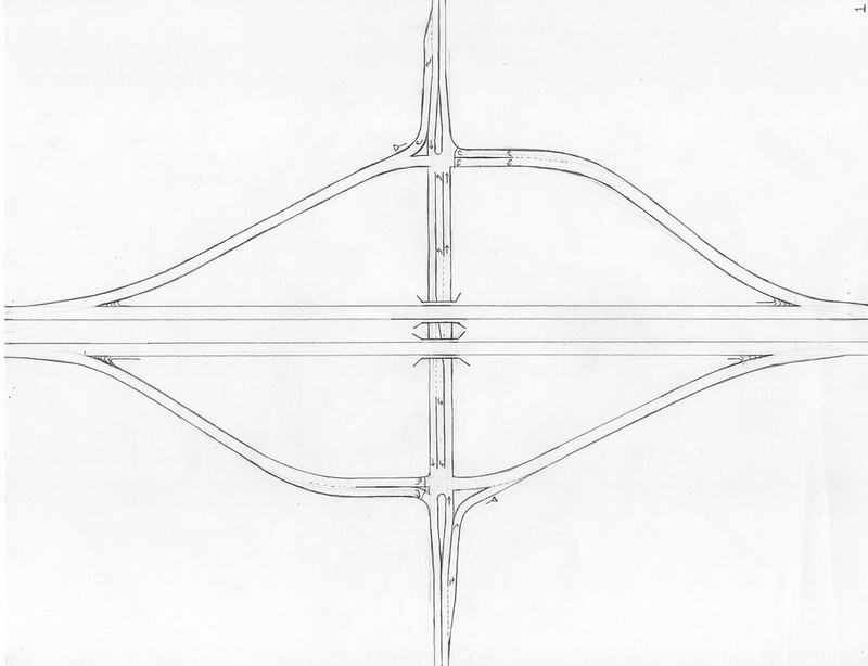
1. The Diamond InterchangeClick the image of the drawing for a larger view.
|
|
The diamond interchange is the most common type of interchange, providing the simplest complete connection between an expressway and a surface road. Each direction of travel along the expressway has an offramp stemming from it, heading straight for an intersection with the surface road; that intersection is also the start of an onramp leading in the same direction of travel. An interchange with a surface road only requires four ramps: an onramp to each direction along the expressway, and an offramp from each direction of the freeway. Two intersections lie along the surface road, one on either side of the overpass, and they both function like intersections with a one-way street. However, no traffic continues straight along these one-way streets; traffic only turns on or off of them. The ramps along a standard diamond interchange hardly need to bend at all. The diamond is the cheapest, simplest interchange that provides a complete connection between two grade-separated roadways, making it very common overall and extremely common in rural areas. Note that the geometric shape of the onramps does not have to match the shape of the offramps, but engineers like to have the onramp meet the surface road at a right angle, to provide user-friendly visibilities. Meeting the onramp at a right angle to the surface road is a general overall rule, to make everything easy to see for a driver without them needing to turn their necks at an unreasonable angle; many diamond interchanges in the most rural areas just have the straightest ramps possible, though, to cut construction costs.
Real-life examples:
Real-life examples:
- Engineered example with perpendicular intersections: I-80 at Wyoming Route 212, Cheyenne, WY (Google StreetView)
- An example with a curving surface road, and the ramps are reworked to meet the surface road perpendicularly: I-20 at Louisiana Route 577, Tallulah, LA (Google StreetView)
- Rural example with cheap, straight ramps: I-90 at South Dakota Route 25, Alexandria, SD (Google StreetView)
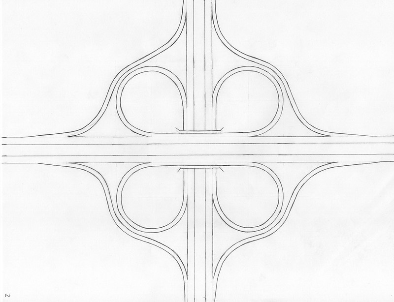
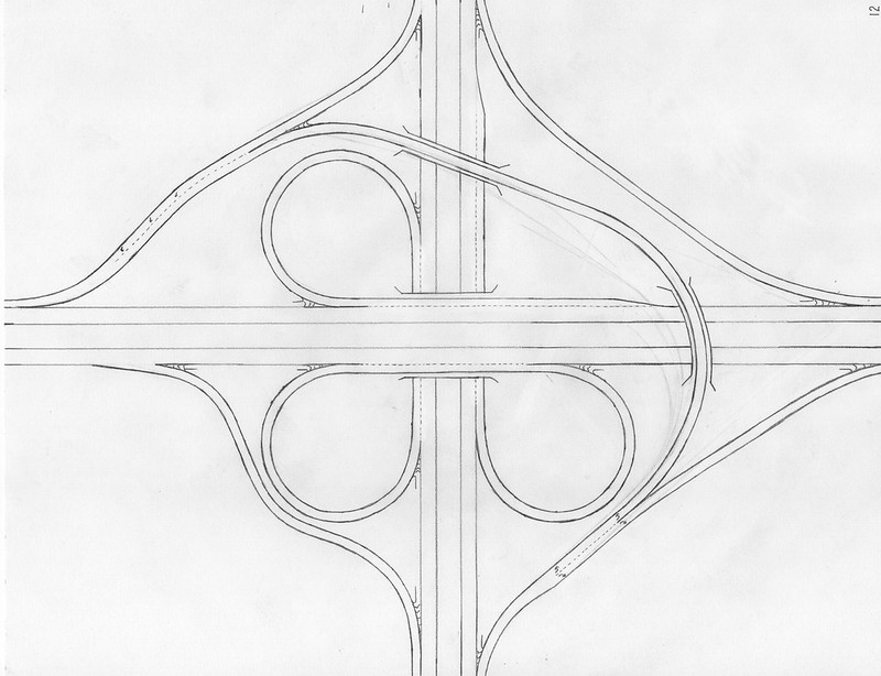
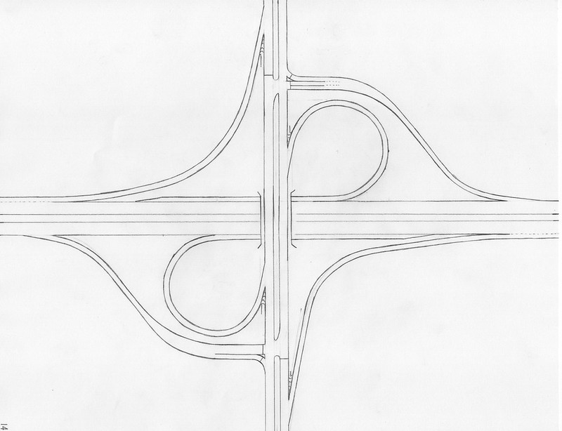
2. The Cloverleaf Interchange |
|
All interchange ramps from an expressway must be directional, so a set of ramps reaching another road must include an onramp to each direction and an offramp from each direction along the freeway. But what it the other road is also an expressway? If we're connecting two expressways, the start of every ramp must be an exit, and the end of every ramp must be a merge onto the destination roadway. We can't have any turns or intersections; the interchange must be completely free-flowing. The classic go-to method for providing a free-flowing interchange is the cloverleaf interchange. The cloverleaf interchange, as with all free-flowing interchanges, has eight ramps; this quantity of ramps serves the purpose of providing the eight turn movements. Consider a north-south expressway meeting an east-west expressway. Going from N-S, S-N, E-W, or W-E just involves going straight. Going from N-E, E-S, S-W, or W-N involves a left turning movement, covered by one of the inner loop ramps shaped like a clover leaf. Going from N-W, W-S, S-E, or E-N requires a right-turning movement, facilitated by one of the outer ramps along the interchange's outer edge. The outer ramps will be a sprawling large diamond allowing faster travel if there's enough space; more compact cloverleaf interchanges will have winding outer ramps, that appear vacuum packed to cling alongside the inner clover leaf ramps. Though cloverleaf interchanges are considered the original standard in fully-directional interchange connections, shortcomings have arisen, making them less preferred by today's designers. The biggest problem with the cloverleaf is with its inner cloverleaf ramps, as they position an entry point to the roadway just before an exit point. Traffic seeking the exit point merges right, as traffic entering the roadway is trying to push left from their onramp onto the expressway; these two sets of traffic cross paths and compete for the same bit of space. If that bit of space has traffic demand that exceeds its small capacity, which is very possible, traffic jams occur--not to mention the traffic accessing the ramps with their tight turns is already holding other people up by slowing down to access those slow-speed ramps.
Real-life examples:
Real-life examples:
- A sprawling example with straight outer ramps: I-35 at US Route 412, Perry, OK (Google StreetView)
- A compressed example with curving outer ramps: I-79 at I-90, Erie, PA (Google StreetView)
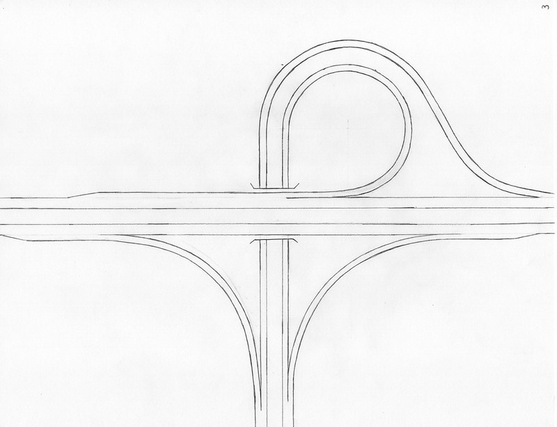
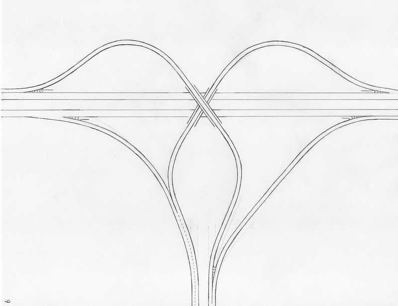
3. The Trumpet Interchange |
|
The trumpet interchange is the essential configuration to know if you want to terminate one roadway at an expressway. The trumpet is the most basic way to end any roadway at an expressway; it doesn't matter if the terminating roadway is a small surface road or a full-on freeway. When deciding to build a trumpet interchange, you can choose between one design or its mirror image; both are valid. Unlike a diamond interchange, the most basic 4-way junction at a surface road, a trumpet road is fully directional, even though it's the simplest design for a 3-way junction. No one needs to wait at any intersections!
Real life example: I-89 at Vermont Route 62, Montpelier, VT (Google StreetView)
Real life example: I-89 at Vermont Route 62, Montpelier, VT (Google StreetView)
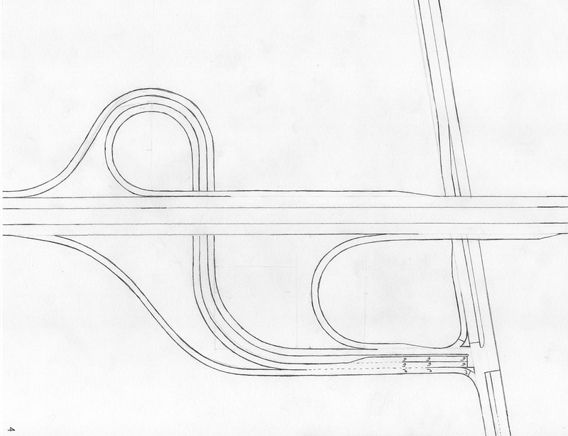
4. The Trumpet Spur |
|
The trumpet spur uses the concept of a trumpet interchange to sprout an access road from the expressway, which spurs away to meet a connecting highway. The point where it meets the connecting highway can be an at-grade intersection, or it can actually be another trumpet interchange. The trumpet spur can be used if only a very specific point along a highway is suitable for constructing the interchange ramps. A common application for trumpet spurs is to provide access to tollways, because the unified access road allows tollway concessioners the money-saving opportunity to construct only one toll booth building, through which all traffic entering and exiting the tollway must pass.
Real-world example: I-90 at New York State Route 98, Batavia, NY (Google StreetView)
Here are some interchanges with ramps meeting at intersections with the surface road:
Real-world example: I-90 at New York State Route 98, Batavia, NY (Google StreetView)
Here are some interchanges with ramps meeting at intersections with the surface road:
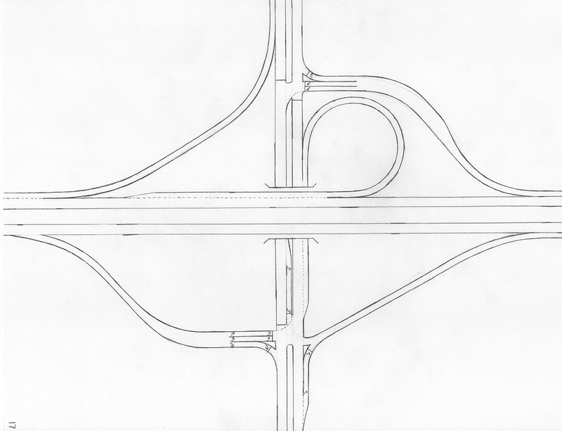
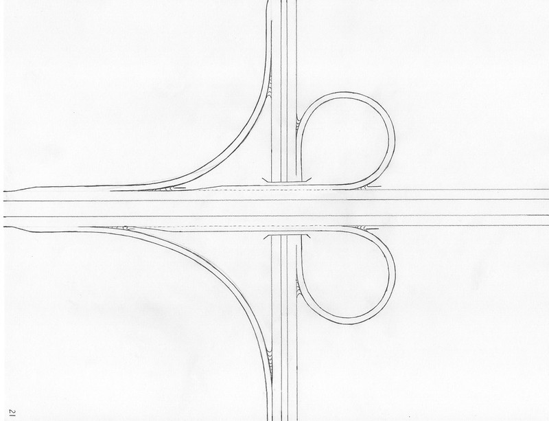
5. The Folded Diamond, or Fountain |
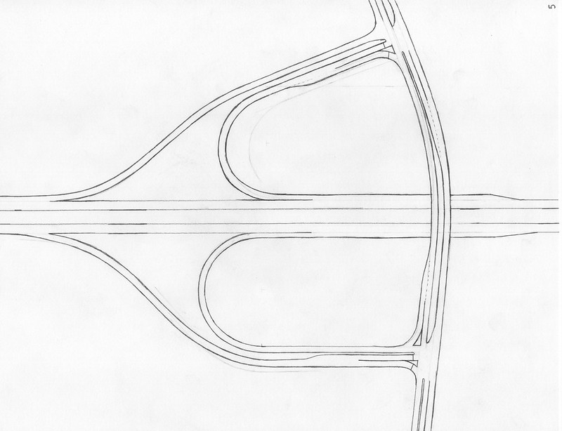
|
In providing access to surface roads, the folded diamond interchange is great for situations where constructing ramps may not be suitable in all four quadrants. What do you do if you want to connect an expressway to a surface road that runs alongside a linear obstacle, like a railroad, a river, or a lakeshore? Well, put both the offramp and the onramp on the side of the surface road-- the side without the obstacle. Streamline everything and simplify the curves, and your final result is the folded diamond. I also call the folded diamond interchange the "fountain interchange", because it looks like a fountain (this is easier to see if the expressway is north-south and the ramps are in the northern two quadrants of the crossing). The interior hook ramps involve 180-degree U-turns; one ramp is an onramp, and the other is an offramp. The remaining two ramps largely hug the outsides of those interior hook ramps. Like a typical diamond interchange, a pair of at-grade intersections lies along the surface road, connecting to the interchange ramps.
Real-life example along a railroad: Interstate 15 at US Route 2 in Shelby, MT (Google StreetView)
Real-life example along a river: Interstate 295 at Rhode Island Route 122, Cumberland, RI (Google StreetView)
Real-life example along a railroad: Interstate 15 at US Route 2 in Shelby, MT (Google StreetView)
Real-life example along a river: Interstate 295 at Rhode Island Route 122, Cumberland, RI (Google StreetView)
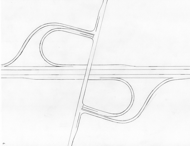
6. The Kitty-Corner Folded Diamond |
|
The folded diamond interchange teaches us that only one quadrant on each side of the expressway must be utilized in order to construct a full interchange with at-grade intersections with the surface road. But what if those quadrants were kitty-corner from each other? Well, it turns out that we can choose any two quadrants to place a pair of ramps--just don't choose a pair on the same side of the expressway, because that would create a redundancy. A fully-functional interchange can, indeed, result from placing a pair of ramps in the northwest corner and another in the southeast corner. You can also put the ramps only in the northeast and southwest corners. Note that with a kitty-corner folded diamond, both the hook ramps with 180-degree U-turns will both consist of both onramps or both offramps. Kitty-corner folded diamonds will often be situated at junctions between highways crossing each other at a skew angle, because the interchange can be set up so that the most-utilized turning movement at the intersections is always the right turn. Right turns are always easier; interchanges like the one in the real-life example put all the dominant turn movements as right turns.
Real-life example: US Route 6 at Massachusetts Highway 124, Harwich, MA (Google StreetView)
Real-life example: US Route 6 at Massachusetts Highway 124, Harwich, MA (Google StreetView)
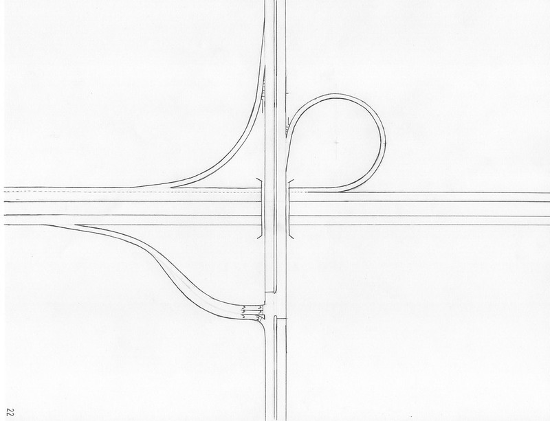
7. The Half-Folded Diamond |
|
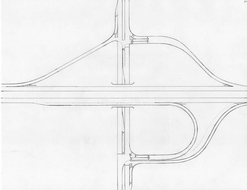
The Half-Folded Diamond is an interchange that uses a standard diamond configuration on one side of the expressway, and a folded diamond configuration on the other side. If only one of the three quadrants at a junction is unsuitable for constructing ramps, a half-folded diamond is a reasonable choice.
Real-life example: I-15 at Utah Route 97, Roy, UT (Google StreetView)
The interchanges in this next category are all completely free-flowing. That means their ramps are all directional, merging onto the destination roadway. What if an expressway meets another expressway, and wants to link with it? Well, you'll need a cloverleaf for a traditional design, or one of these interchanges:
8. The StackClick any interchange drawing for a closer view.
|
|
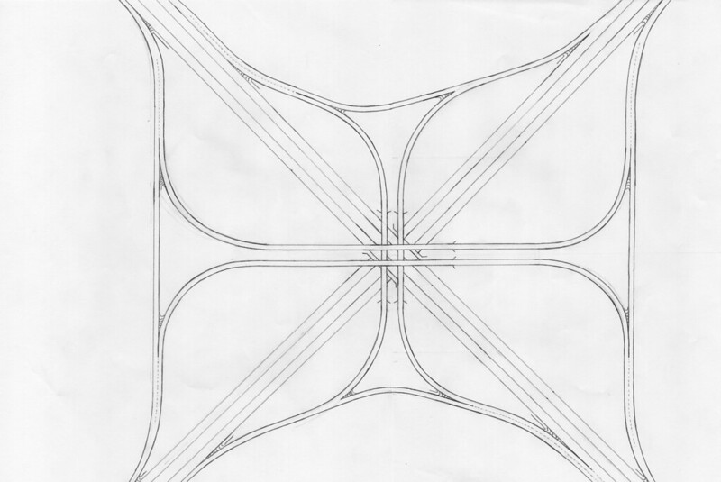
This category will discuss free-flowing interchanges with exclusively directional ramps, other than the cloverleaf interchange. Most will be modifications to the cloverleaf, to replace the left-turning cloverleaf ramps with left-turning flyover ramps, which move traffic through much more quickly. But what if we cheat and just replace all four left-turning ramps with flyovers? Well, that option is called the full stack interchange, and it has to have four levels in the center. The right-turning ramps are on the outer perimeter of the interchange, just like on a cloverleaf. The left-turning ramps originating from one highway cross over the top of the interchange at a third level, above the mainline highways crossing at the first and second levels; the left-turning ramps originating from the other highway cross over the top of all that at a fourth level. Stack interchanges are very expensive, because four flyover ramps have to be built hoisting four different roadways into the sky; two of them are very high into the sky. The allowance of fast motion for all left-turning traffic will lead some DOT's to decide that a full stack interchange is worth it, however. Some stack interchanges use a broader footprint to spread the ramps around more, allowing for a configuration that doesn't require four stories of roadway.
Real-life example: I-10 at I-37 in San Antonio, TX (Google StreetView)
Real-life example: I-10 at I-37 in San Antonio, TX (Google StreetView)
9. The Terminal Stack |
|
When a trumpet doesn't give the efficiency desired, a terminal stack may be in order. Terminal stack interchanges are recommended specifically when there's a high volume of traffic using both left turning movements. Like with some full stack interchanges, some terminal stacks are pulled around to separate the horizontal position of the overpasses, so the flyover ramps don't exactly "stack", per se. A terminal stack will only have three levels maximum, with the two left-turning ramps flying over the entire thru-highway or just one of its carriageways. Sometimes, the footprint occupied by one of the left-turning flyover ramps will be compressed so the other ramp can wrap around it; this avoids the need to stack things three levels high.
Real-life example: I-79 at I-68 in Morgantown, WV (Google StreetView)
Real-life example: I-79 at I-68 in Morgantown, WV (Google StreetView)
10. Three Flyovers |
|
This interchange configuration, and the next two on the list, are hybrids between a cloverleaf interchange and a full stack, with some of the left-turning cloverleaf ramps replaced by faster flyovers. This entry in the list covers the contingency of interchanges using three flyover ramps, with just one cloverleaf ramp remaining. Presumably, the turning movement facilitated by the remaining cloverleaf ramp is the least-used left-turning movement in the mix. Often, when two or three flyovers are used in an interchange, the flyover ramps won't cross over the mainline highways right over the point where the mainline highways cross. This happens frequently in interchanges with all four flyovers, too, but it's difficult to feel justified calling the interchange a "stack" when the pairs of ramps aren't stacked on top of each other.
Real-life example: I-70 and I-75 in Dayton, OH (Google StreetView)
Real-life example: I-70 and I-75 in Dayton, OH (Google StreetView)
11. Two Flyovers |
|
Now, we're down to two flyover ramps replacing the tight-turning cloverleaves. It's possible to choose any two left-turning ramps to make into flyovers; engineers will choose to upgrade whichever ramps need the boost in speed or capacity. If the two left-turning flyover ramps originate from either direction along the same expressway, you can stack them over the junction point of the two highways, like in a full stack revised to only have three stories. In any situation where the left-turning flyovers come from opposite directions on the same highway, the two remaining cloverleaf ramps will be kitty-corner from each other. Otherwise, when the two left-turning flyovers originate from two legs 90 degrees apart from each other, the two remaining cloverleaves will sit in adjoining quadrants. In this other situation, the flyover ramps usually wrap around the periphery of the junction of the two mainlines, rather than passing right over it.
Real-life example:
Real-life example:
- With two consecutive flyovers: I-70 at I-465, west side of Indianapolis, IN (Google StreetView)
- With two opposing flyovers: I-540 at US Route 70 in Raleigh, NC (Google StreetView)
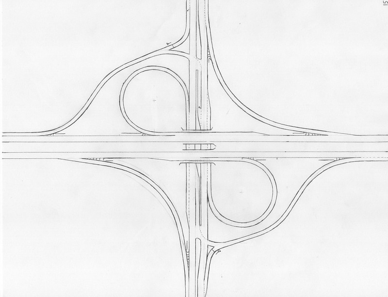
12. One-Flyover Cloverleaf |
|
This is essentially a cloverleaf interchange with one cloverleaf replaced by a left-turning flyover ramp. Perhaps the engineers anticipated one heavily-used turning movement back and forth through this interchange. Consider a fully-directional interchange between two highways, where a lot of traffic moves between one particular leg of one highway and one particular leg of the other highway. The heavily-used right-turning movement is easier to hook up with higher speeds, since it's on the outside edge of the interchange; however, the left-turning movement, traditionally given a tight cloverleaf turn, needs a major reworking in order to allow higher speeds and higher throughput. Widening a cloverleaf ramp is largely a fruitless endeavor; a much better solution is to increase the speed of the ramp to increase throughput (a faster roadway or ramp serves more vehicles per minute!). Cloverleaf ramps need to run slowly because of the tight turn radius, so speeding things up is very possible when you replace it with a flyover ramp. A cloverleaf with one left-turning flyover probably has a heavily-traffic pair of turning movements between two particular legs of the junction. Some such interchanges have the flyover removed to the exterior of the interchange, so no points need to occupy more than two levels stacked on top of each other; others move the flyover on top of everything.
Real-life examples:
Real-life examples:
- With the flyover on top: I-29 at I-94 in Fargo, ND (Google StreetView)
- With the flyover removed to the outside: I-96 at US Route 127, Lansing, MI (Google StreetView)
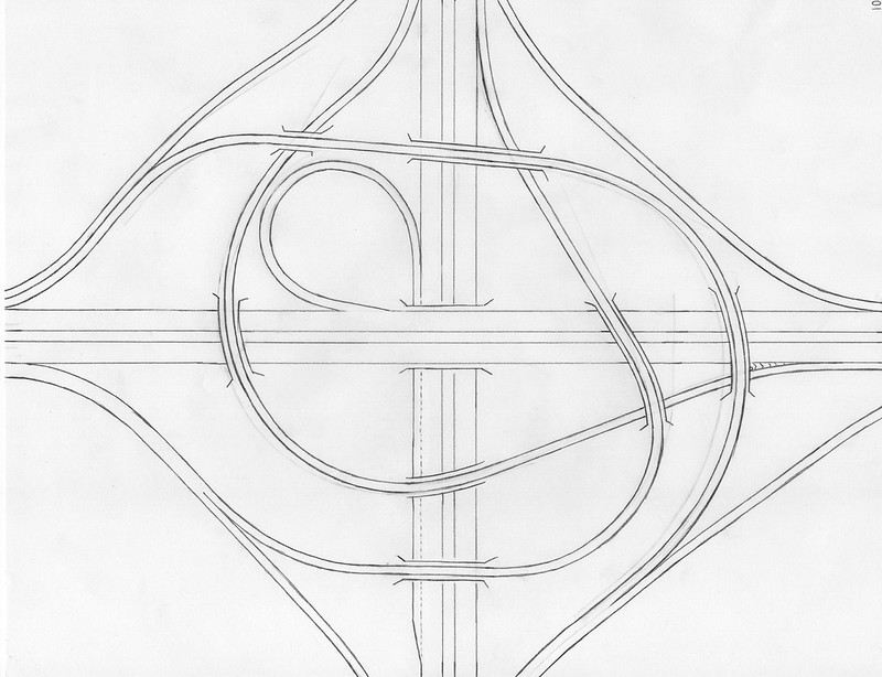
13. The "Central Inner Turbine"**(I made this name up. I don't think there's a proper name for this interchange, but because I like its design, I'm including it in the list.)
|
|
This interchange is a modified version of the two-flyover retrofitted cloverleaf interchange, but the highways expand to allow space between the carriageways, and the flyovers are transformed into interior ramps located in the center of the junction. Allowing expressway exits and entrances to appear on the driver's left can add a whole new dimension to interchange designs--if you choose to allow them. Many engineers and road fans view left-exits and left-entrances as a scourge. But if you approve of their usage, the first thing to know about a ramp stemming from the left side of a carriageway is that the oncoming lanes must be a good distance away; you can't build a ramp off to the left of a carriageway if the oncoming traffic is right there alongside that carriageway. That means that any highway with left-oriented entrances or exits must have a large space provided between the carriageways, and the widening to create this space must be fairly long on a fast-paced highway requiring gradual bends. This leads to a major disadvantage of interchanges with left-oriented entrances and exits; they take up a lot of space with their separated carriageways. The left-turning ramps at the center of this interchange start as left-oriented exits and end as left-oriented entrances, meaning both highways have to bow out to create space between the carriageways.
Real-life examples:
That concludes the category of free-flowing interchanges. The next category includes interchanges that are hybrids between a diamond and a cloverleaf; they have some ramps meeting at at-grade intersections, and some directional ramps. Because they have any at-grade intersections at all, though, these interchanges can only be used between an expressway and a surface road. Some refer to all interchanges in this category as "Parclos," a portmanteau of "partial cloverleaves". "Parclo" is an apt name for these, because they incorporate some ramps from the standard cloverleaf interchange.
Real-life examples:
- I-77 at I-70 in Cambridge, OH (Google StreetView)
- I-57 at I-80 in Country Club Hills, south of Chicago, IL (Google StreetView)
That concludes the category of free-flowing interchanges. The next category includes interchanges that are hybrids between a diamond and a cloverleaf; they have some ramps meeting at at-grade intersections, and some directional ramps. Because they have any at-grade intersections at all, though, these interchanges can only be used between an expressway and a surface road. Some refer to all interchanges in this category as "Parclos," a portmanteau of "partial cloverleaves". "Parclo" is an apt name for these, because they incorporate some ramps from the standard cloverleaf interchange.
14. Parclo with All Directional Onramps |
|
What if you want an interchange where the offramps meet the surface road at intersections, but the onramps to the freeway are directional? Well, this interchange option is a real option, and it's used very widely in certain areas. This is the first interchange listed in a series of "Parclo" interchanges, which is shorthand for "partial cloverleaf" interchange. You won't typically find this interchange design in rural areas, as it is more robust and expensive as your economy-value diamond interchange. But in suburban areas, these interchanges can appear very frequently. They occupy a larger footprint, so you might not see them quite so often tightly-packed urban areas. The suburban environment is just right for this interchange design to be chosen. Modifying a diamond interchange into one of these partial cloverleaf interchanges starts with taking each onramp and replacing each one with a pair of directional onramps to the freeway. Each pair of onramps diverging from a direction along the surface road will consist of a right-turning ramp and a left-turning tight cloverleaf ramp. The right-turning onramp will be the only ramp occupying its quadrant of the junction. The left-turning cloverleaf will sit at the interior of one of the two offramps that meet at an intersection. Often, at interchanges like this, the start point of the right-turning onramp will be moved to an earlier point, so that traffic using it doesn't have to deal with the intersection with the offramp on that side of the expressway.
Real-life example: I-55 at Mississippi Route 302, Southaven, MS (Google StreetView)
Real-life example: I-55 at Mississippi Route 302, Southaven, MS (Google StreetView)
15. Parclo with All Directional Offramps (not so much a thing) |
|
The possibility exists to create an alternative to the previous interchange in the list, with directional offramps instead of directional onramps. However, this possibility is almost never manifested. If a six-ramp interchange is to be constructed, DOTs prefer to spend their money splitting the onramps into directional pairs, rather than splitting the offramps into directional pairs. This is because, with respect to the surface road, it is wiser to choose an at-grade intersection with incoming offramp traffic, than it is to choose an at-grade intersection with outgoing onramp traffic. The decision to build an interchange more elaborate than your plain, typical diamond comes from a need to serve a greater traffic volume moving between the two crossing roadways. An offramp meeting an intersection with the surface road provides an opportunity to control the offramp traffic making a left on the surface road. A parclo with directional offramps forces traffic to enter the surface road from the right, when they might need to make a left turn soon after using the ramp. On the other hand, a parclo with directional onramps provides the option of warning surface road traffic that they have to keep right to reach the onramps.
Real-life example: Interstate 96 at Michigan Route 11, Grand Rapids, MI. (Google StreetView)
Real-life example: Interstate 96 at Michigan Route 11, Grand Rapids, MI. (Google StreetView)
16. Parclo Directional to One Leg |
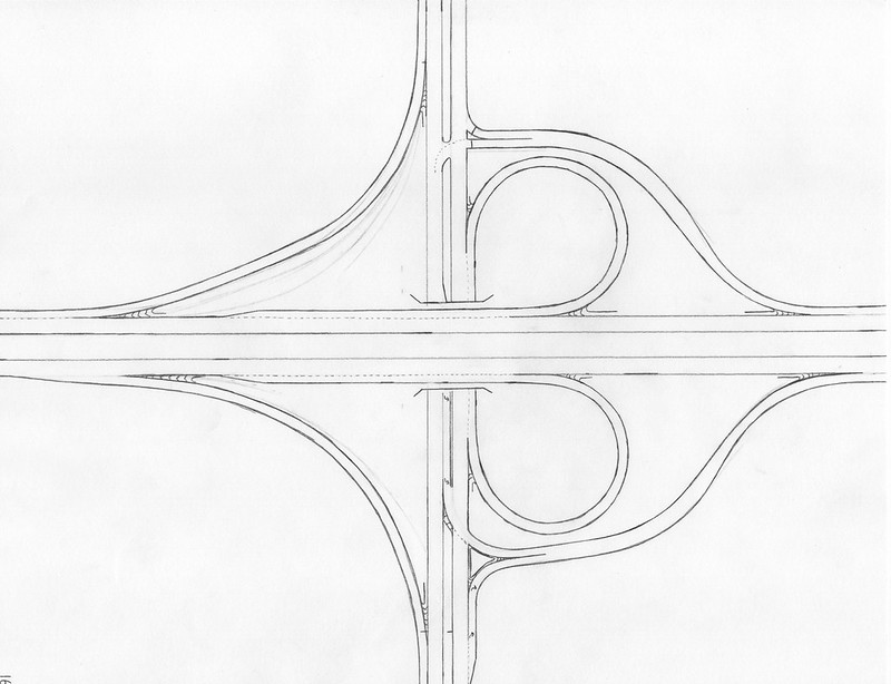
|
What if we made an interchange between an expressway and a surface road, with free-flowing ramps accessing to and from one leg of the expressway, but with plain diamond-interchange ramps aimed at the other leg of the expressway? Would this be a good interchange design if a sizeable majority of traffic connecting between the two roadways seeks to access one particular leg of the expressway? Some DOTs appear to think so. See interchange #21 below, as this interchange is #21 with two standard diamond ramps tenting over the less-traveled end of the expressway. This variety of Parclo interchange runs the risk of creating weave issues, as it has cloverleaf ramps in consecutive quadrants; at least the weave issues are along the surface road and not the primary highway, though. One at-grade intersection is with an offramp, and one is with an onramp.
Real-life example: I-540 at Arkansas Route 22 in Fort Smith, AR (Google StreetView)
Real-life example: I-540 at Arkansas Route 22 in Fort Smith, AR (Google StreetView)
17. One Pair of Directional Onramps |
|
Maybe only one turning movement at an interchange needs adjustments to accommodate a high volume of traffic. As you may have determined by now, enhancing right-turning movements at an interchange is much easier, because all you have to do is add lanes and streamline that right turn. On the other hand, enhancing left-turning movements at an interchange is much more difficult, with directional cloverleaf ramps and left-turning flyovers serving as the commonly-cited incremental improvements. Some interchanges that could otherwise be diamonds are reimagined to have just one pair of directional onramps toward one carriageway of the expressway, and this is almost always because of one popular pair of opposing turning movements. In the real-life example mentioned, the greatest proportion of traffic is trying to move between the northern and western legs of the interchange. This determines the position of the cloverleaf ramp, whose purposes is to provide a directional non-stop left-turning movement. The reverse of this turning movement, from the north leg to the west leg, is easily served by the southbound offramp and a right turn. This marginal upgrade from a diamond interchange really helps if there's one heavily-traveled pair of opposite movements between a pair of legs at the interchange (that aren't just heading straight).
Real-life example: I-H3 at Hawaii Route 83, Kaneohe, HI (Google StreetView)
Example of an interchange with a pair of directional offramps instead: I-15 at Nevada Highway 592, Las Vegas, NV (Google StreetView)
Real-life example: I-H3 at Hawaii Route 83, Kaneohe, HI (Google StreetView)
Example of an interchange with a pair of directional offramps instead: I-15 at Nevada Highway 592, Las Vegas, NV (Google StreetView)
18. Volleyball |
|
The volleyball interchange is begrudgingly included in this list, because they're either wastefully expensive or traps in my opinion. It isn't even really shaped like a volleyball. "Volleyball interchange" is a term used to describe an interchange where ramps split to form alternate collector lanes from all four carriageways; these four alternate collector ramps meet at some tertiary elevation, forming four intersections arranged in the shape of a hash mark (or pound sign). This type of interchange looks like it will lead to good things, because the only connections to either highway involved are either onramps are offramps. However, the four at-grade intersections suspended in the sky will quickly become jammed if there's too much throughput through the ramps. Some DOTs try to rectify this by replacing the square of four intersections with a roundabout, which works better. Another adaptation is to keep the ramps tightly alongside the mainline portions of highway, keeping the four intersections tightly packed together so they resemble a single interchange between two two-way roads. This type of interchange is uncommon because of the significant increase in cost, caused by the fact that a stack of three levels has to occur to build it. Queueing traffic at an at-grade intersection, or at four of them, where the traffic backs onto the offramps from two expressways, is a dangerous proposition, because we really don't want those queues backing up stopped traffic onto a super-fast expressway! Volleyball interchanges must never be used in places with high traffic volumes, and if an interchange should only be built in low-volume rural situations, a low-volume interchange probably shouldn't warrant spending the funds necessary to construct a three-level stacked-up interchange such as this one.
Real-life example: I-41 at Wisconsin Highway 190 in Wauwatosa, WI (Google StreetView)
The next category is partial interchanges. These only allow partial access, but interchanges like this are built this way by design. No one ever said that a complete connection had to be installed at every crossing!
19. Half-Diamond |
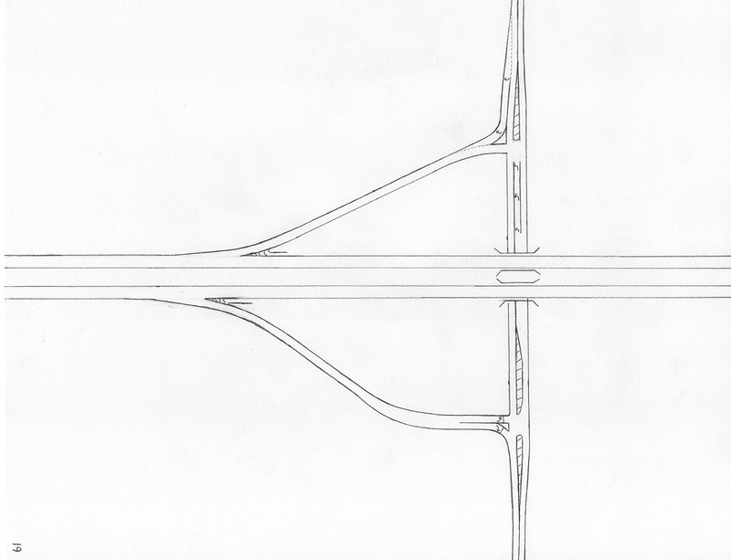
|
This is exactly what it sounds like: a diamond interchange with half of it deleted. The deleted half and the remaining half lie on either sides of the surface road, so the surface road has access to and from one leg of the expressway. This pair of ramps forms one half of many of the various complete interchanges on this list. Sometimes DOTs will opt for only an interchange that provides access to a surface road to/from one leg of an expressway. This might be because traffic on the other leg of the expressway may be less inclined to access the surface road and vice versa; it might also be because another partial interchange to the other leg of the expressway is established nearby.
Real-life example: Delaware Tollway Route 1 at Delaware Route 8 in Dover, DE (Google StreetView)
Real-life example: Delaware Tollway Route 1 at Delaware Route 8 in Dover, DE (Google StreetView)
20. Half-Fountain |
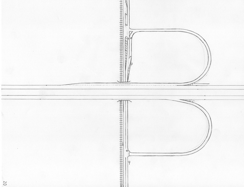
|
This partial interchange also provides access to and from one leg of the expressway, but the ramps are the interior hairpin ramps from a folded diamond or fountain interchange. Another partial interchange of a similar nature can result from a single hairpin ramp and a single plain diamond interchange ramp, arranged kitty-corner from each other so they aim at the same direction down the expressway. Offramp traffic will be controlled by a stop sign or signal, but since there's only one offramp at these partial interchanges, this only happens once at the interchange.
Real-life example: I-94 at Illinois Route 176, Libertyville, IL (Google StreetView)
Real-life example: I-94 at Illinois Route 176, Libertyville, IL (Google StreetView)
21. One-Leg Parclo |
|
What if we take the ramps from a cloverleaf interchange, and delete the ones involving one leg of the expressway? That's a valid interchange, though it's a partial interchange, of course. This interchange consists of four ramps, with one in each of the four quadrants of the junction. The quadrants on one side of the surface road each have a cloverleaf ramp, and the consecutive cloverleaf ramps can create weave issues on the surface road. One carriageway of the expressway has two exits, whereas the other carriageway has two entrances and no exits. Of all the half-access interchanges, this is the one to choose for a pair of limited-access highways. If you take one cloverleaf and replace it with a flyover that wraps around, you get a sort of trumpet interchange that serves a four-way junction.
Real-life example: Connecticut Route 15 at US Route 7, Norwalk, CT (Google StreetView)
Real-life example: Connecticut Route 15 at US Route 7, Norwalk, CT (Google StreetView)
22. One-Leg Semi-Directional |
|
The previous interchange can have one pair of ramps on one side of the expressway converted into a single ramp. Maybe we would like to keep the onramps directional, but the offramps can revert to the single offramp as in the diamond interchange. Well, we can do just that! Like with the Parclo interchanges, the ramps split into directional pairs will probably be the onramps, not the offramps.
Real-life example: I-88 and Illinois Route 53, Lisle, IL (Google StreetView)
Real-life example: I-88 and Illinois Route 53, Lisle, IL (Google StreetView)
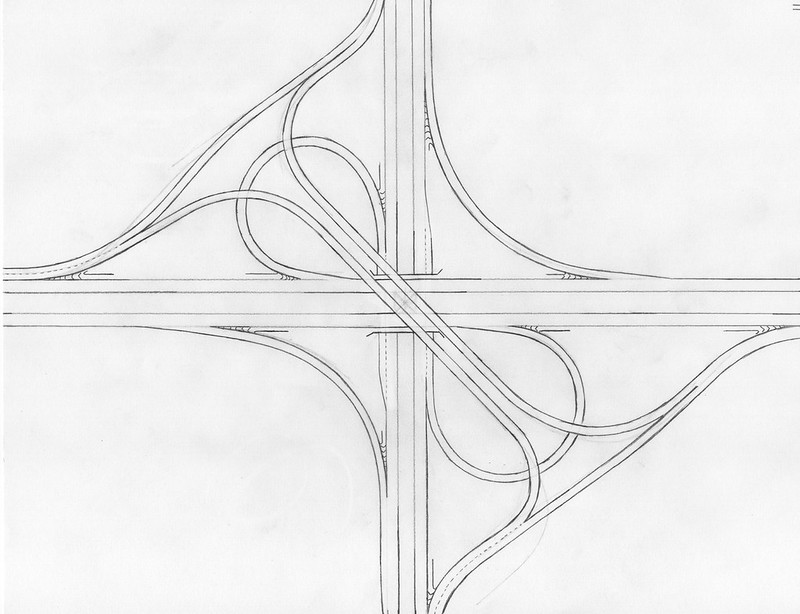
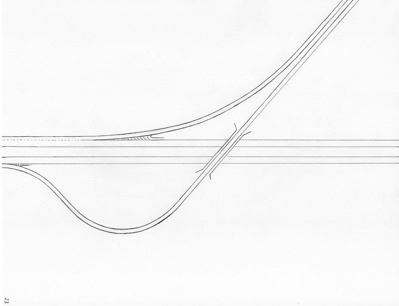
23. Two-Ramp Split |
|
The two-ramp split only facilitates movement between a terminating roadway and a thru roadway, but only one leg of that thru roadway. This is a fork in the road, where access down the offshoot is only provided to and from a single direction. Most people seeking to reach this offshoot are probably coming from one direction on the thru road, anyway. Splits from an expressway to an alternate business alignment will often take the form of this simple configuration. The two-ramp split has two forms: one where the exit and the entrance both appear on the driver's right, and one where one of the ramps appears on the driver's left. Both forms involve the use of one single bridge crossing, so they're equally viable and roughly equal in cost.
Real-life examples:
The last section of interchanges here is to show some newly-popular concepts.
Real-life examples:
- I-65 at Tennessee Route 386 in Goodlettsville, TN (style 1) (Google StreetView);
- I-26 at I-385, Clinton, SC (style 2) (Google StreetView)
The last section of interchanges here is to show some newly-popular concepts.
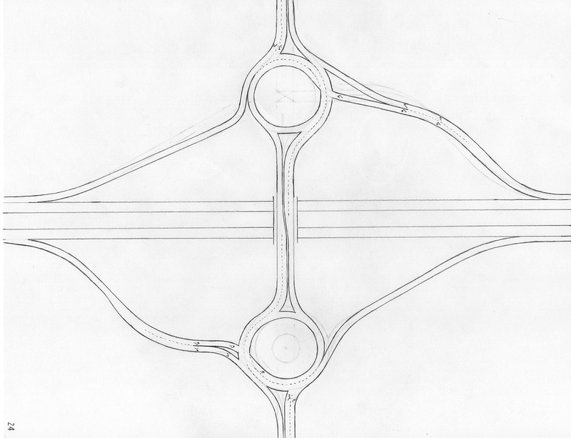
24. The Dumbbell |
|
This entry in the list and the next entry both involve the concept of roundabouts. If you were to combine the idea of a diamond interchange with the idea of roundabouts, the first thing you imagine might be a diamond interchange, but with a roundabout at each of its two at-grade intersections. Well, that's exactly what the dumbbell interchange is! The dumbbell interchange, or barbell interchange, is a diamond interchange retrofitted with roundabouts at the two intersections. The barbell interchange might not be appropriate for very heavily-used diamond interchanges, but then again, diamond interchanges as a whole aren't suitable when traffic volumes are too monstrously high! Each roundabout has three points of ingress and three points of egress; two points of ingress and two points of egress are just the surface road continuing onward. Barbell interchanges can also be formed out of retrofitting other alternatives to the diamond interchange, using roundabouts at the at-grade intersections. Folded diamonds, kitty-corner folded diamonds, and half-folded diamonds can all get the roundabout treatment.
Real-life example: I-87 at New York Route 67, Malta, NY (Google StreetView)
Real-life example: I-87 at New York Route 67, Malta, NY (Google StreetView)
25. The Dogbone |
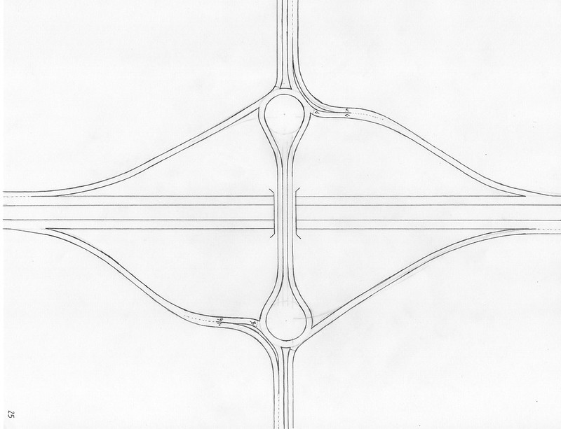
|
Another diamond interchange reconfigured with roundabout technology is the dogbone interchange. Consider a diamond interchange, with a single large rotary joining all traffic, encompassing a large enough area to incorporate both intersection points. If the surface road passes over the expressway, this situation would require a big rotary on two expensive, curved bridges elevated over the expressway. To avoid building two bridges, the rotary is reshaped by pinching it down to a narrow shape with two flared ends, like a dog-bone. The final product ends up very similar to the dumbbell interchange, but the interior quarter (toward the expressway) of each roundabout on the dumbbell is removed. No one was using that little interior snippet of the roundabouts anyway! Note that if the large, unified rotary takes place below the grade of the expressway, some DOT's will still build the rotary as a big circle.
Real-life example: Keystone Parkway at 126th Street, at Carmel, IN (Google StreetView)
Real-life example: Keystone Parkway at 126th Street, at Carmel, IN (Google StreetView)
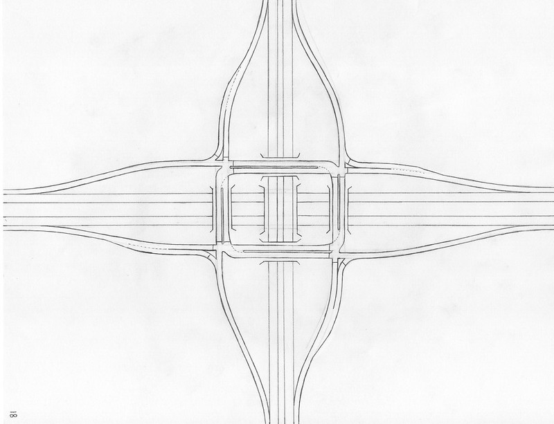
26. The Single-Point Urban Interchange(SPUI) |
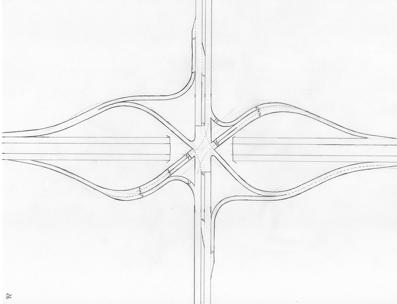
|
The single-point urban interchange, or SPUI, improves upon the design of the classic diamond interchange. One shortcoming of diamond interchanges is that they set up two intersection points along the surface road, and often, those points are rather close together. Putting multiple busy intersections close together is a recipe for traffic backups, and the intersections at expressway interchanges are always the busiest intersections in an area. What if I told you, we can combine both intersections from a traditional diamond interchange into a single access point? Even better, the single access point functions as a four-way intersection, as each pair of ramps coming from one leg of the expressway forms a sort of two-way leg of the intersection. The only problem is that, as the ramps meet the single point from four different angles besides the two angles occupied by the surface road, a very large bridge must be constructed. Either that bridge is a wide structure above the expressway, or it's a long bridge carrying the expressway over the large intersection of the surface road and the ramps. Turns from the ramps to the surface road and vice versa occupy a very wide radius, and following the right pathing can be challenging for turning drivers.
Real-life example: I-25 at US Route 550, Bernalillo, NM (Google StreetView)
Real-life example: I-25 at US Route 550, Bernalillo, NM (Google StreetView)
27. The Diverging Diamond Interchange(DDI) |
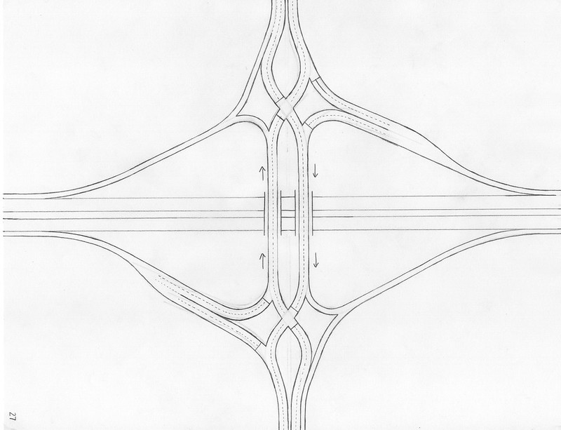
|
The diverging diamond interchange, or "DDI", is a seemingly convoluted configuration that occupies much the same footprint as a traditional diamond interchange. Notably, this interchange has a quirk forcing surface road traffic to cross to the left side of the roadway between the two ramp access points. This may seem appalling at first, seeing vehicles use the opposite side of the road from what you're used to seeing. However, this traffic configuration presents two major advantages. The first advantage is that all turning movements at the intersections, besides the surface road traffic's crossover to the other side of the road, are splits or merges that don't have to cross over another channel of traffic to reach their intended destination. This removes conflict points that require a signal to have more phases. And on that note, the second advantage is that neither traffic signal needs to have any more than two signal phases. At a typical diamond interchange, the signal at each of the two intersections needs to have three phases: a phase for the offramp traffic, a left-turning phase for traffic seeking to access the onramp, and a thru-phase for surface road traffic. A reduction in the number of signal phases means less traffic queueing at red lights--the probability of hitting a green light, roughly speaking, is increased from 33% to 50% at a diverging diamond interchange.
Real-life example: US Route 60 at Missouri Route 13, Springfield, MO (Google StreetView)
Of course, there are many more interchange configurations possible, and even within the realm of practical, efficient interchange designs lie many options that are commonly and rightfully used. If there are other reasonably common tropes you see within the world of interchange configurations, and you would like to see them on this page, send an email to the webmaster at [email protected] ...maybe I'll add more interchanges to write about on this page!
|
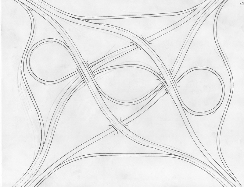
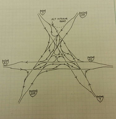
And if you're wondering about this image shown on the front page, this is a six-way interchange I designed when I was in high school. I used it as the basis of an engineering design project. The idea of three freeways coming together at the same point is a rather unlikely proposition, but that didn't stop me from trying to solve that problem before it manifests! The interchange has a very broad footprint, but it works! Every potential ramp connection is there.
|
|
